Document Dump: Columbus' Official Blueprints for Hudson Street Bike Path
- Download the plans
- Where can you find out official information?
- When does work start?
- Where and when are the road closures?
- Hours of construction
- What's in the construction plans?
- What do the intersections look like?
- What's the bike path like?
- Wouldn't it be nice if…?
- Why this post?
The City of Columbus is finally moving forward with the Hudson Street bike lane from I-71 to Cleveland Avenue. On March 23, 2022, the Council passed Ordinance 0485-2022 to fund the project.
What's included in the project? The funding ordinance has this to say:
This contract includes reconstructing Hudson Street from I-71 to Cleveland Avenue. The reconstruction will include installing new curb, full pavement reconstruction, reconstruction and modification to the existing median on the east leg of the I-71 at the Hudson Street intersection, sidewalk on the north side, a shared used path on the south side, street trees, new traffic signals, storm sewers, a new 24” water main, new ADA curb ramps at intersections, and other work as may be necessary to complete the contract in accordance with the plans and specifications set forth in the Bid Submittal Documents.
I acquired a copy of the Bid Submittal Documents to find out everything that's in the plans.
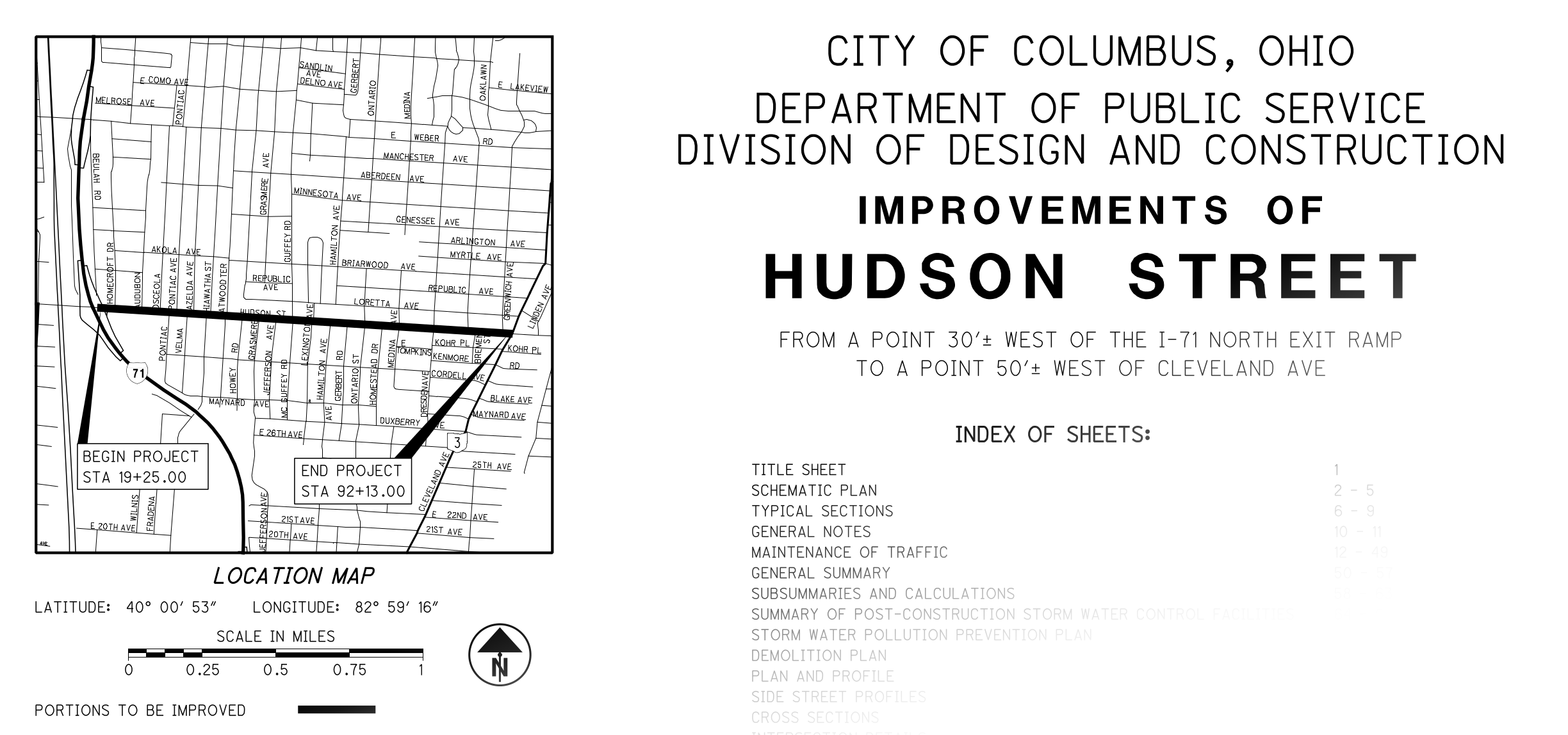
You can keep scrolling and view the screenshots with my commentary, or you can download the full plans to find the bits that will affect you. I'll include references to page numbers in the plans document, to help you find additional information there.
Download the plans
Download the plans (135MB PDF)
How official is this PDF? Well, it comes from the office of Councilmember Lourdes Barroso de Padilla, chair of the Public Service Committee, who sponsored the $19,395,049.60 ordinance that approved the project. I think it's pretty legitimate.
Where can you find out official information?
If you live on Hudson, or operate a business on Hudson, I expect that the city will notify you whenever they feel like notifying you.
When does work start?
The City's project fact sheets page says that construction will run from spring 2022 to summer 2024, subject to funding and weather. The city's 2020 Fact Sheet for the project shows the following phases:
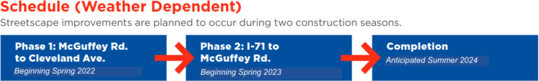
They'll work east to west, and wrap up sometime in 2024. But when in 2022 does work start?
To double-check, I asked the Department of Neighborhoods. They forwarded me a link to The Columbus Dispatch's article, which doesn't have firmer dates.
I asked Columbus 311; they emailed the following:
Per your inquiry, we have been told by the Division of Design and Construction project manager that they have not yet had their spring project meeting that will happen sometime around the end of April, so the project will most likely start sometime in May after the pipes are ordered and delivered.
If you live between Hudson and Weber, now is the time to start getting comfortable making left turns on to westbound Weber. When construction starts, the project will block westbound traffic on Hudson.
Where and when are the road closures?
Plan for westbound Hudson Street to be closed from Cleveland to McGuffey in 2022, and from McGuffey to I-71 in 2023. Here's the individual phases of the project, as detailed on page 13 of the plans:
Utility Pre-Phase 1
Traffic:
- Maintain one lane of eastbound Hudson Street Traffic at all times. Shift traffic as needed to perform work.
Construction:
- Construct proposed water line between Jefferson Avenue and Cleveland Avenue.
- Construct proposed storm trunk line replacement between Sta. 83+50 and Sta. 90 + 70.
The storm trunk line replacement appears to be between Dresden Street and Cleveland Avenue, if I'm reading page 5 right.
Phase 1
Traffic:
- Maintain one lane of eastbound Hudson Street Traffic at all times. Shift traffic as needed to perform work.
- Detour westbound Hudson Street traffic by routing to Weber Road.
Construction:
- Construct the north and south portions of proposed Hudson Street in sub-phases (1A and 1B, respectively) from just west of McGuffey Road East to Cleveland Avenue, including sidewalk.
For more about phases 1A and 1B, see pages 17-22 of the plans. The "phases" are how the document talks about which side of Hudson is being worked on. Phase 1A is the north side of Hudson; Phase 1B is the south side of Hudson.
Utility Pre-Phase 2
Traffic:
- Maintain one lane of eastbound Hudson Street Traffic at all times. Shift traffic as needed to perform work.
- Detour westbound Hudson Street traffic by routing to Weber Road.
Construction:
- Construct remainder of proposed water line between I-71 NB ramp and Jefferson Avenue.
I'm not sure why the water main work is broken out into its own "pre-phases", unless that work won't involve tearing up the streets.
Phase 2
Traffic:
- Maintain one lane of eastbound Hudson Street Traffic at all times. Shift traffic as needed to perform work.
- Detour westbound Hudson Street traffic by routing to Weber Road.
Construction:
- Construct the north and south portions of proposed Hudson Street in two sub-phases (2A and 2B, respectively) between I-71 exit ramp to McGuffey Road. Work is to include sidewalk construction.
For more about phases 2A and 2B, see pages 23-36 of the plans. Phase 2A works on the north side of Hudson; Phase 2B works on the south side of Hudson. Phases 2A and 2B are further broken down into steps, which have to do how traffic is routed at the I-71 ramp intersection. In Phase 2B Step 2, there's no right turn from I-71 onto Hudson eastbound.
Key Takeaway: Westbound traffic will detour to Weber. Only eastbound drivers will be permitted on Hudson for duration of the project.
Pedestrians: It looks like sidewalks will be maintained on one side of Hudson at all times.
COTA Riders: The plans don't say what will happen to COTA service during the project, sorry. Contact COTA, ask your driver, and keep an eye on COTA's service changes page
Hours of construction
One other neat tidbit on page 13:
Hours of Operation in ROW:
Allowable hours for work shall be from 9 AM to 3 PM, M-F, all day Saturday & Sunday.
I guess they're trying to avoid conflicts with rush-hour traffic.
Key Takeaway: They probably won't disturb your sleep.
Page 12 of the plan says no work on OSU football home game days, Christmas, New Year's (day or eve? unclear), the 4th of July and Red White and Boom, Memorial Day, Labor Day, or Thanksgiving.
Temporary side street and driveway closures
On page 15, we learn more about closures of roads and driveways intersecting Hudson:
Side street closures shall only occur from 9AM to 4 PM, Monday through Friday. No two, or more, side streets shall be closed at the same time.
There shall be at least one access to commercial properties when closing driveways. Side street access is acceptable. The commercial property owner/manager shall be notified 48 hours in advance of closure.
Residential driveways shall only be closed between 9AM and 4PM, Monday through Friday. The resident shall be notified 48 hours in advance of closure.
If you want to peep how traffic patterns will change during this time, here's where you can find the traffic-cone layouts and temporary street signs in the plans PDF:
| Phase | Work | Pages |
|---|---|---|
| 1A | McGuffey to Cleveland, south side of Hudson | 17-19 |
| 1B | McGuffey to Cleveland, north side of Hudson | 20-22 |
| 2A | I-71 to McGuffey, south side of Hudson | 23-29 |
| 2A | I-71 to McGuffey, north side of Hudson | 30-36 |
What's in the construction plans?
- Street signs, including bus stop placements (pages 408-418)
- New concrete pads for bus stops (pages 408-418)
- New storm drains, including silva cells located under the bike path to temporarily hold water during heavy rain (pages 64, 68-72)
- 73 new or replacement street trees (459-463)
- Tree protection: "All public trees whether shown or not shown on the plans are to be preserved unless approval to remove or prune is given in writing by Columbus Recreation & Parks/City Forester or their removal has been designated on the plan." (page 10)
- Detailed road cross-sections and driveway designs (pages 180-253)
- Detailed curb and sidewalk plans (pages 254-307, 314-335)
- New stair steps for house walkways (pages 308-313)
- New storm sewers, water mains, and fire hydrants (pages 336-392)
- Traffic signal changes and timings (pages 426-443)
- Traffic signal interconnection details, including fiber and Cat5e Ethernet wiring diagrams (pages 444-459)
- Property map, including owner names (pages 470-473)
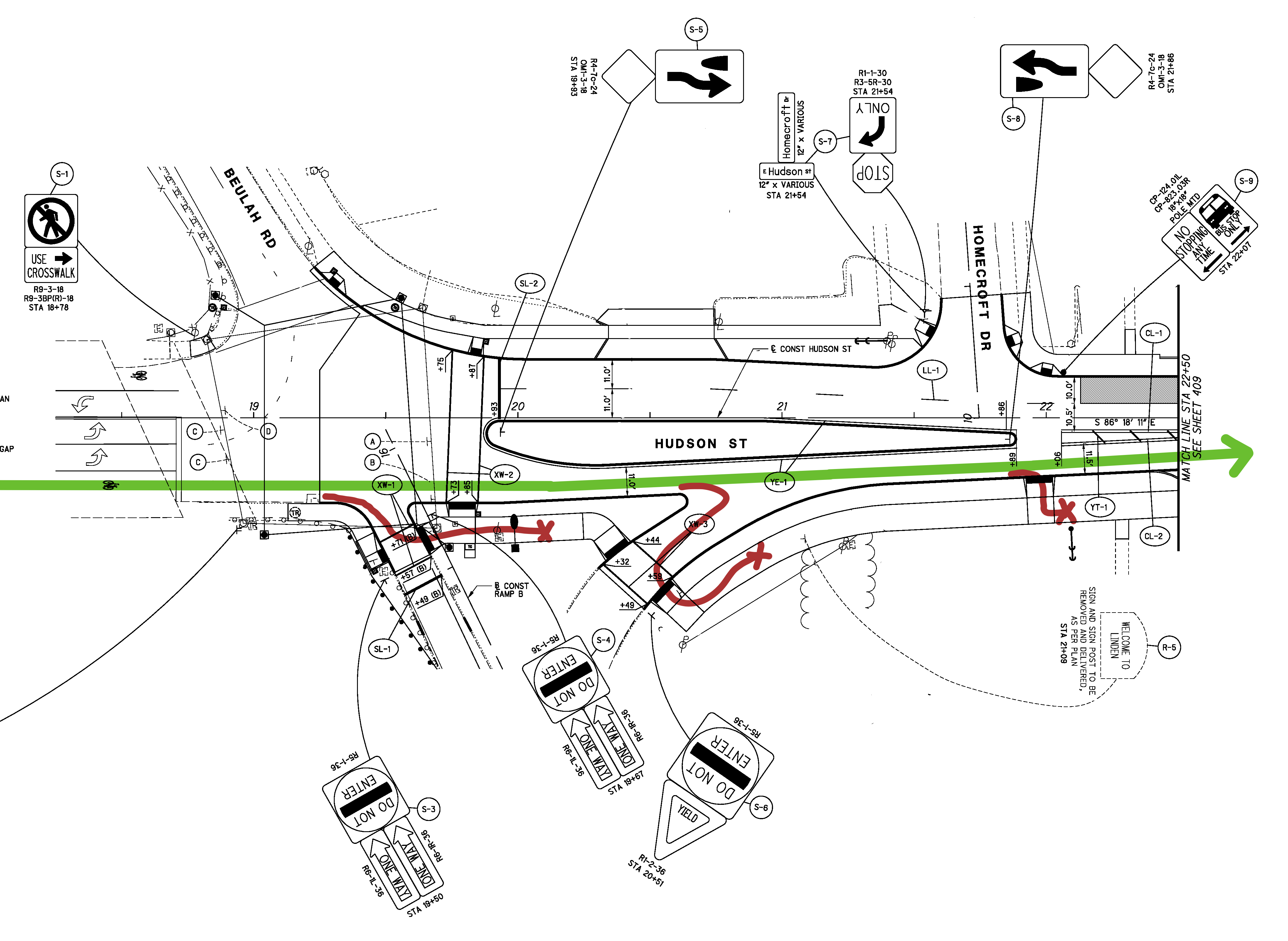
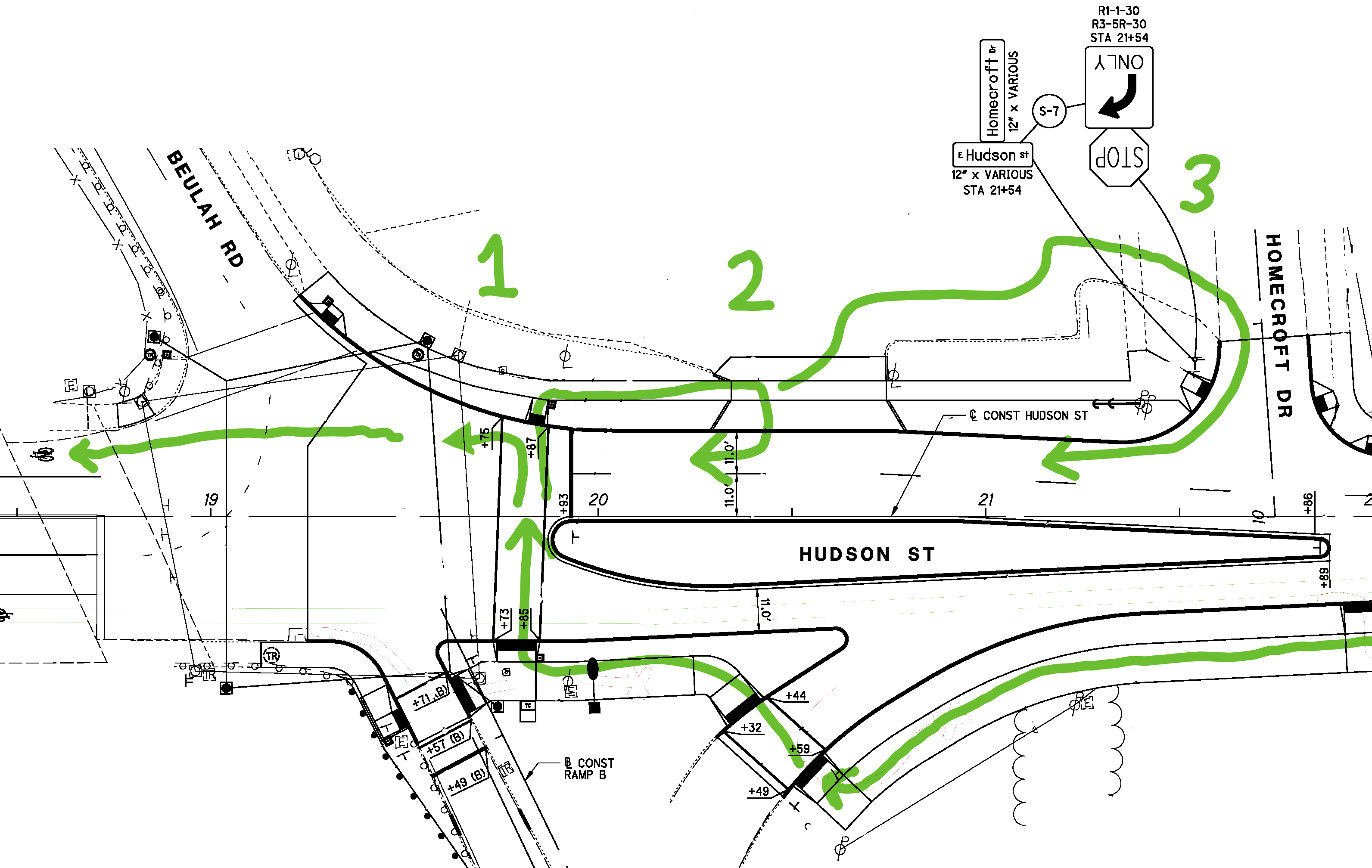
What do the intersections look like?
If you want the details of a particular intersection, check out the full plans that I linked at the start of this post. Generally speaking, any given intersection's biggest change will be that Hudson Street has moved north by a few feet. As a result, the plans include redoing sidewalks, driveways, signs, and crosswalks.
The intersections with the largest changes are at the east and west ends of East Hudson Street, where it meets I-71 and Cleveland Avenue.
Hudson and I-71
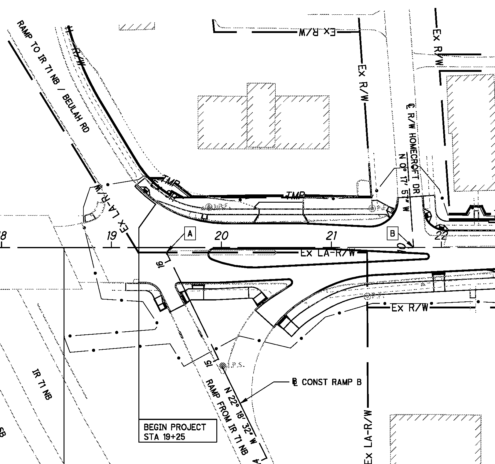
Notable changes in the new design:
- The concrete median on Hudson has widened and lengthened.
- There is no longer space for aggressive drivers to pass slow vehicles headed eastbound. The widened median blocks passing. Where before there had been two lanes of pavement, one of which was closed with paint, now there is only one lane of pavement.
- The longer median blocks left turns from eastbound Hudson onto Homecroft Drive. There are currently signs which prohibit that turn, but after the reconstruction, that turn is no longer physically possible. A six-inch curb blocks turns. To get to Homecroft, drivers should take Beulah Road or Audubon Road, and then turn onto Homecroft via a neighborhood cross-street.
- Some truly wacky drivers used to cut across Hudson from the I-71 ramp right into the Shell gas station. The longer median blocks those turns, too. Shell should put a sign on the ramp directing drivers to go straight through the light and then turn right, or else risk losing customers to the Marathon down the street.
- The longer median also blocks left turns from Homecroft Drive onto eastbound Hudson. This use was permitted in the old design for the road, and is no longer possible.
- The shared-use bike path begins at the sidewalk crossing on the south side of the ramp. The shared-use path is basically a pleasantly-wide sidewalk.
- No traffic controls are given to make it easier for bicyclists headed westbound to enter the westbound vehicle traffic flow; it looks like bicyclists will need to cross Hudson at the crosswalk, then enter the road from the crosswalk, the Shell gas station parking lot, or from Homecroft.
- No traffic controls or even pavement paths are given to let cyclists enter the shared-use path. The easiest spot to do that appears to be the driveways of the Family Dollar, Wendy's, hotel, or Columbus City Schools warehouse.
- The Hudson crosswalk used to cross the median; now it crosses the intersection in front of the median.
I think they should've extended the median further to the west, to allow a spot for pedestrians to wait in the middle of Hudson. And they should've added a bicycle turn box. But I also know that drivers love to creep forward at this intersection, and the end of the median is an indication of where cars should stop moving forward, so the choice the engineers made here makes sense.
For more details of this intersection, check out these pages in the PDF:
- Overall design: page 2
- Curb design: pages 254-257
- Traffic control signs: page 408
- Traffic signal installation and timings: page 427-430
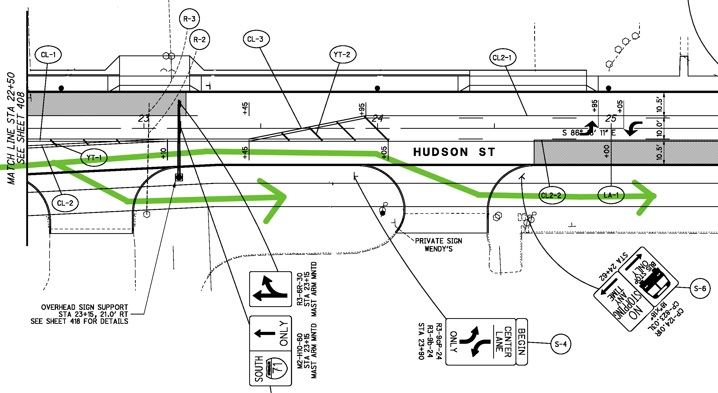
Hudson and Cleveland
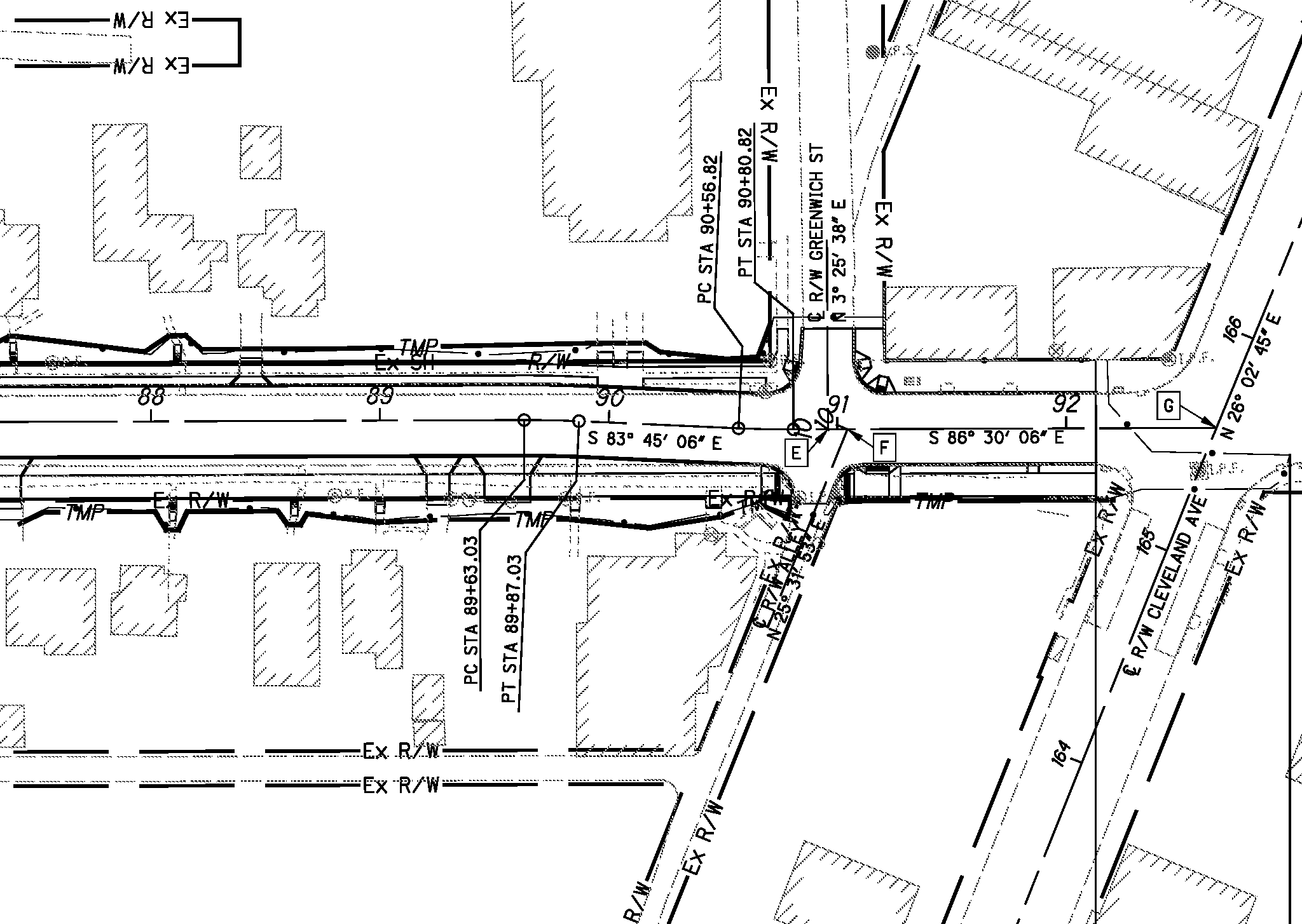
The Cleveland Avenue end of Hudson doesn't have much in the way of large changes; just a nice curve where the realigned Hudson edges closer to the shared-use path. The shared-use path continues across Cleveland Avenue at the crosswalk.
For more details of this intersection, check out these pages in the PDF:
- Overall design: page 5
- Curb design: page 281
- Traffic control signs: page 417
- Traffic signal modifications: page 443
What's the bike path like?
It's better than the current setup, but I don't envy people who will try to use the bike path to commute.
Here's two sample bike trail use cases, both crossing North Linden on Hudson:
- Eastbound on Hudson from Clintonville towards the Alum Creek Trail
- Westbound from Hudson from East Linden to the Summit Avenue protected bike lane
Most of what I write below is applicable to people using scooters, hoverboards, mobility aids, strollers, wagons, shopping carts, and really any mode of travel that isn't a car or truck. Bikes and scooters stand out as modes of transit that are banned by law from riding on sidewalks, so I go into more detail about how to manage moving from the shared-use path to the road and back again. But once you're on the shared-use path, we'll all be using it together.
Eastbound
If you're coming from the west on Hudson, you have to deal with the bridge over I-71. The bike lane stops in the middle of the intersection; you must merge with motor vehicle traffic or jump the curb to get onto the bridge's narrow sidewalk.
Since bicycling on the sidewalk is illegal in Columbus, I'll assume that you stay in the 35mph travel lane, riding centered on the bike arrows in the middle of the lane. The driver behind you may decide to honk impatiently. Bicyclists have a right to use the road, same as anyone else.
On the east side of the intersection, there's no easy off-ramp for bicyclists into the new shared-use path. All the curb ramps for the shared-use path are in places where you'd need to ride into oncoming I-71 offramp traffic to get to the shared-use path, so you continue riding in the 35mph travel lane.
At the first opportunity, you exit the road and get onto the shared-use path via a driveway.
Wave to the generous drivers at Family Dollar or Wendy's, or continue in traffic a little while longer, and use the lower-traffic driveways for the hotel or the Columbus city schools warehouse.
I'd expect most bicyclists to be on the shared-used trail at this point, because Hudson remains a 35mph road in these plans. The smooth new pavement will invite higher speeds, and aggressive drivers will use the center turn lane to pass when possible.
As a bicyclist, you must use unmarked crosswalks to cross Pontiac Street, Velma Avenue, Hiawatha Park Drive, Atwood Terrace, Howey Road, Grasmere Avenue, and Jefferson Avenue.
If you're headed north on the Hiawatha Street bike boulevard, there are no pavement marks or signs for the crosswalk across Hudson (pages 265, 411). Keep an eye out for cars, because those drivers are probably not paying attention to you!
(Maybe this oversight will be fixed with the dedicated Hiawatha Park Drive shared-use path, planned for 2024-2025.)
McGuffey Avenue has a traffic light, so wait there for the pedestrian signal to cross.
Lexington Avenue has no light or marked crosswalk. Hamilton Avenue has a stoplight and crosswalk. Gerbert Road, Ontario Street, Homestead Drive, and Medina Avenue do not. Dresden Street has a light and crosswalk. Bremen Street and Greenwich Street do not.
Finally, you reach Cleveland Avenue. The shared-use path continues across Cleveland Avenue via the pedestrian crosswalk, so you will need to dodge people waiting at bus stops for the routes 11, 31, 6 and CMAX COTA buses.
So now that we've crossed Cleveland, let's turn around, and head to Clintonville.
Westbound
Bicyclists heading westbound on Hudson from Cleveland Avenue will need to decide where they're going to enter the shared-use path. The easiest way will probably be to use a crosswalk signal at Cleveland Avenue to cross to the south side of Hudson, or at McGuffey. Hiawatha bike boulevard users will need to wait for a break in traffic to cross at the uncontrolled intersection.
At the western end of the shared use trail, bicyclists can continue to the dedicated bike lane on Hudson on the west side of I-71. Getting to that bike lane is a problem and this project does not really address it.
Here are three possible routes for shared-use path bicyclists to get to the bike lane on the east side of I-71:
- Cross Hudson on the crosswalk, then use the crosswalk as an improvised bike turn box to position yourself ahead of motor vehicle traffic at the light. Wait for the light to turn green, cross the bridge.
- Cross Hudson at the crosswalk, then bike on the sidewalk until you reach the gas-station parking lot driveway. Turn left from the parking lot and merge with traffic.
- Cross Hudson at the crosswalk, then bike through the gas-station parking lot to Homecroft Drive. Turn left from Homecroft onto Hudson, and merge with traffic.
After you've crossed the bridge, keep right to stay in the marked, unprotected bike lane.
Merge into the travel lanes at the intersection of Hudson and Summit Avenue, and stay right until you get to the intersection with Summit Street. Swerve north into the bike box on Summit Street, then wait for the light to change (and maybe press the pedestrian walk button).
If you're not comfortable riding in traffic: Walk your bike across the I-71 bridge and across the Silver Drive crosswalk. Walk your bike west on Hudson until you reach the protected bike lanes on Summit.
Wouldn't it be nice if…?
- if there were a dedicated bike lane on the Hudson bridge over I-71, to keep bikes separate from motorized vehicles?
- if there were a greenways bike trail down the disused rail right-of-way that roughly parallels Cleveland-Westerville Road, leading all the way to downtown? Or, better yet, a trolley line?
- if there were a dedicated bike lane on Parkwood Avenue and Mock Road, so bicyclists and pedestrians don't have to use the street?
- if the Willis Athletic Complex on Mock Road had a bridge connecting it to the adjacent Alum Creek Trail, so bicyclists and joggers and people with strollers could enter the trail there? The current alternatives include a tiny pull-off on Sunbury Road, an apartment parking lot off Sunbury, and a lot of walking or biking along the unimproved shoulders of roads.
Projects for another day.
In the meantime, we can look forward to the 2024-2025 Hiawatha Park Drive shared-use path, which will cut under I-71, allowing bicyclists to avoid the I-71 bridge's dangerous merges.
Why this post?
Because this new shared-use path seems like an exciting addition to Columbus' existing bike infrastructure. It's the first connection between the Olentangy River Trail and the Alum Creek Trail that doesn't require bicyclists to route through downtown or fight for space with inconsiderate drivers.
Because people were talking about the construction project and I got interested enough to ask for the docs.
Because, having the docs, I felt an obligation to share them with the wider community.