Notes from the Cleveland Avenue Pedestrian Improvements meeting on May 24
- Why are changes coming to Cleveland Avenue?
- What's next on Cleveland Avenue?
- What will the completed work look like?
- Where can I learn more about these projects?
- How can I provide feedback or comments on the upcoming work?
- How can I stay up to date on upcoming infrastructure work?
On May 24, The City of Columbus held a public meeting at St. Stephen's Community House about upcoming projects to improve the pedestrian infrastructure on Cleveland Avenue. You may have heard about them adding some crosswalks; this meeting was about that and more.
I made a map of all the new crosswalk locations, if you want to skip straight to that.
Why are changes coming to Cleveland Avenue?
Residents of Linden may have seen Walk Safe On Cleveland campaign materials, asking people to keep families safe on #TheAve. It's part of Columbus' Vision Zero campaign to eliminate traffic deaths.
According to Walk Safe On Cleveland, a vehicle on Cleveland Avenue hits a pedestrian every 23 days, on average. Half of pedestrian crashes occur when people aren't crossing at an intersection. A handout from the Franklin County Engineer's Office distributed at the meeting describes the traffic situation on Cleveland Avenue from the Northern Lights shopping center north to Pegg Road:
Businesses, COTA stops, and community activity create a lot of pedestrian traffic in the Cleveland Avenue area. These pedestrians need safe crossing locations. In the past, there have been more pedestrian crashes here than in other nearby areas. From 2016-2018, 14 crashes involved pedestrians, including 2 who were killed. From 2016-2018, there were 111 rear end crashes and 120 left turn crashes.
Cleveland Avenue is particularly dangerous because it's a wide, high-traffic, high-speed road that lacks protected crosswalks, street lights, or separated bike lanes. The City has not added a protected bike lane or reduced the speed limit. Columbus is already installing street lights.
The only thing left to do is upgrade the crosswalks.
What's next on Cleveland Avenue?
The City of Columbus and Franklin County are teaming up to:
- Redo seven crosswalks on Cleveland Avenue
- Camden Avenue
- 19th Avenue
- Kenmore Road, installing a "Pedestrian Hybrid Beacon" crosswalk near the Linden library
- Republic Avenue, in front of the Family Dollar
- Lakeview Avenue, at Gye Nyame Place where the North Linden Area Commission used to hold meetings
- Agler Road, connecting the apartments at Kenmore Place to New Salem Baptist Church and to a northbound bus stop — people have been asking for this crosswalk since Kenmore Place was in the planning stages
- Lehner Road, by the Northern Lights library, which gets the second Pedestrian Hybrid Beacon
- Add five crosswalks to the Northern Lights shopping center area, each with a concrete island in the middle of the road so that pedestrians only have to cross two lanes at once:
- At the Fifth Third Bank between Huy Road and Innis Road
- Between the Wendy's and the Popeye's
- At the combination Long John Silver's and A&W
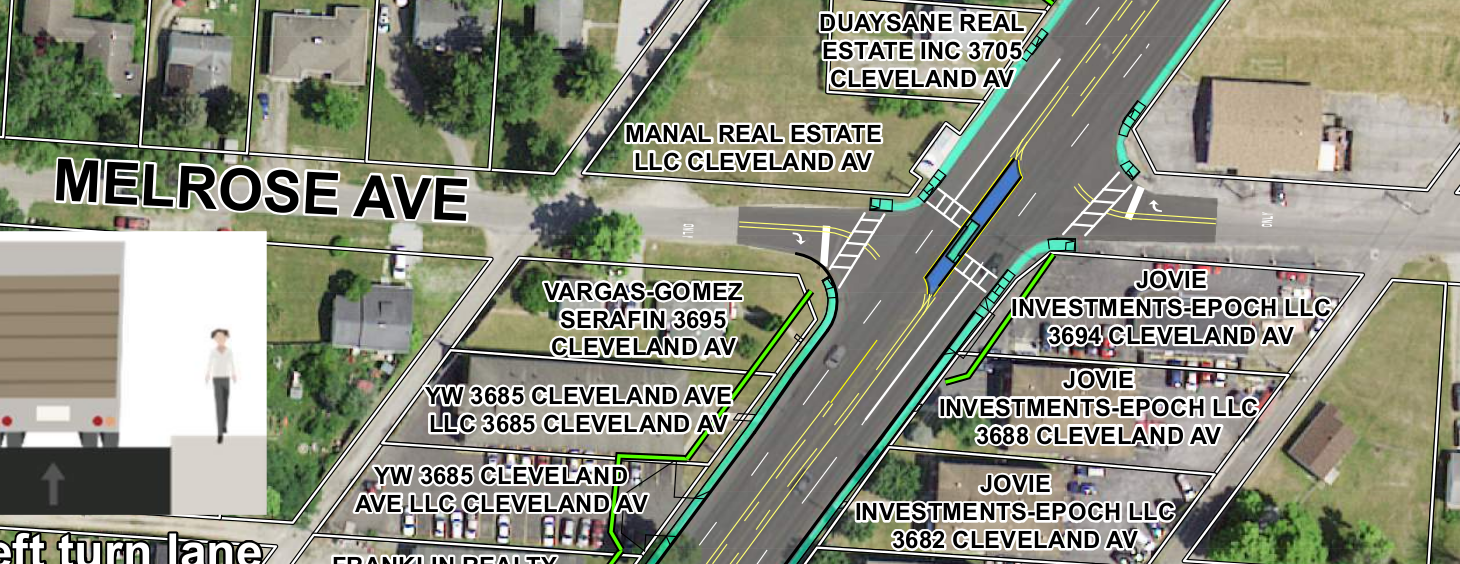
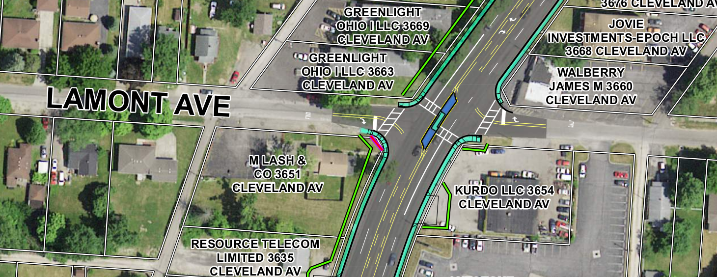
- At Lamont Avenue, blocking traffic on Lamont across Cleveland Avenue
- At Melrose Avenue, blocking traffic on Melrose across Cleveland Avenue
- Add concrete medians with tree plantings to block left turns from parking lots across Cleveland Avenue, but not blocking left turns from Cleveland Avenue:
- Between Huy Road and Innis Road
- Between Innis Road and the northern end of Northern Lights, south of Elmore Avenue
- Between the northern end of Northern Lights and Elmore Avenue
- At Lamont Avenue
- At Melrose Avenue
- Add a concrete median on Innis Road in order to block:
- Left turns from eastbound Innis Road into Amos Center
- Left turns from Cleveland Innis Plaza onto westbound Innis Road
- Reduce lane widths on Cleveland Avenue through the Northern Lights shopping center from 12 feet to 10 feet, which will slow traffic while still providing plenty of elbow room for even the widest of street-legal trucks.
Not addressed at this meeting: A potential redesign of the Cleveland and Myrtle Avenue intersection. There's also a project proposal floating around for changes to the Cleveland Avenue intersection with Hudson, but I can't find it anymore.
ODOT has a few projects planned in the area as well: redoing the intersection of Westerville Avenue and Morse Road,
What will the completed work look like?
When will construction happen?
Expected schedule for the Columbus portion of the work (403 kB PDF), the crosswalks from Camden to Agler and at Northern Lights Library:
- Design work is expected to complete in December 2022.
- Because the new crosswalk signage and signals require poles, Columbus will have to buy some land abutting the crosswalks to place the signs and relocated sidewalks on. This right-of-way acquisition phase is expected to wrap up in winter 2022-2023.
- Construction begins summer 2023, and wraps up summer 2024.
The schedule for the Franklin County Engineer portion of the work, the crosswalks at Northern Lights shopping center and Lamont and Melrose, is less firm, according to a FCE employee at the meeting. A FCE flyer explaining the project (535 kB PDF)) says that construction is scheduled between June and December 2024.
Rectangular Rapid Flashing Beacons
Columbus and Franklin County will install Rectangular Rapid Flashing Beacons at many of these crosswalks.
Rectangular Rapid Flashing Beacons look like this:
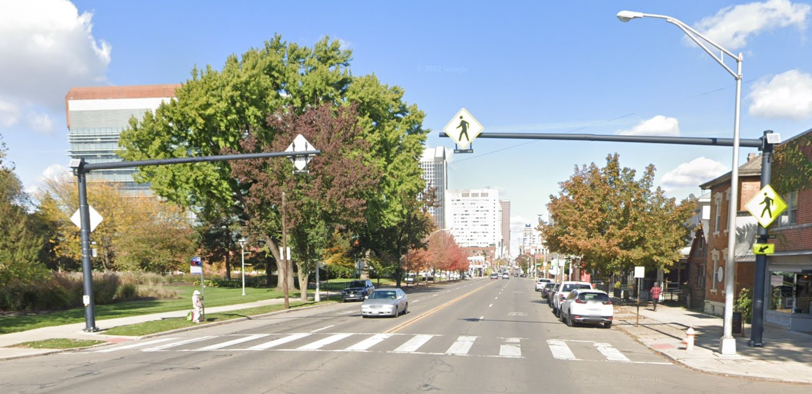
When you press the walk button, yellow flashers come on on the overhead pole and at both sides of the street. The blinkers come on immediately. Look both ways before crossing the street.
If you don't want to travel to South High Street, a closer RRFB can be found on Summit Street south of Hudson Street.
Pedestrian Hybrid Beacons
Pedestrian Hybrid Beacons, sometimes called "HAWK signals", are a new form of traffic signal. There are two red lights above one yellow light, and the signal head only lights up when a pedestrian presses the button.
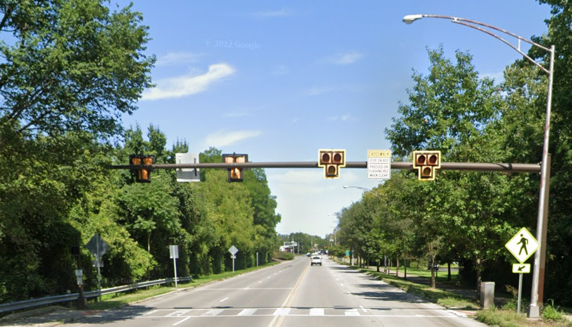
Pedestrians using a PHB crosswalk will have a walk light like you see at standard intersections, with an orange hand, a white pedestrian, and a countdown timer.
This is what drivers see:
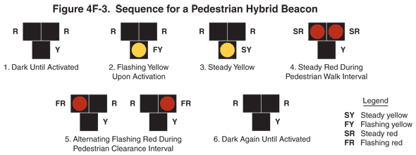
When a pedestrian presses the beg button, the signal shown to drivers does this: First, the bottom light starts flashing yellow ("proceed with caution"). Then it turns solid yellow ("prepare to stop"). Then the two top lights come on red ("stop") and stay solid red for a while, before switching to the left and right lamps flashing red alternately, which in the context of a PHB signal means "stop, then proceed when the crosswalk is clear." Eventually, the whole signal head goes dark, which means "proceed with caution". The signal stays dark until another pedestrian presses the button. For a longer description of the sequence, see the FHWA MUTCD description of the signal, which is where this diagram comes from.
In every other situation where you encounter alternating flashing red lights, like at fire station signals, train crossings, drawbridges, and school buses, alternating flashing red lights means stop and remain stopped. I don't like how PHBs change the meaning of alternating flashing red lights, but there's very little we can do to change that.
(Well, we could petition the Federal Highway Administration to change the Manual on Uniform Traffic Control Devices.)
If you'd like to see one of these PHBs in play, check out North 4th Street nust north of 20th Avenue, and Morse Road between Westerville Road and Sunbury Road.
Why not install full traffic lights?
This is a complicated issue. People I spoke to at the meeting said it had to deal with "warrants". In order to install a new traffic light, federal and state DOT standards require an intersection or crosswalk to meet certain criteria, which are described generally on the ODOT traffic signal requests page and more specifically in Part 4C of the Ohio Manual on Uniform Traffic Control Devices)
None of these crosswalks or intersections have met the criteria that will justify a traffic light. My guess is that there isn't yet enough pedestrian traffic across Cleveland Avenue to justify full traffic lights. Therefore, they're installing the PHBs and RRFBs. PHBs have milder criteria than traffic lights, and RRFBs have lower criteria than PHBs.
There is a form of traffic light designed for mid-block crossings, called a "midblock signal". There are too many cross streets on Cleveland Avenue to use this design, so what would be installed instead is called a "half signal" where the cross street has a stop sign. The traffic light remains green unless a pedestrian or vehicle is present. Half signals aren't approved of by the federal Manual on Uniform Traffic Control Devices, and for good reason: drivers see the green light so often that they become used to it, and ignore it when it changes to yellow or red.
Pedestrian refuges and other medians blocking left turns
The full details are in this map of the Franklin County Engineer's Office project (6.5 MB PDF).
The project's goal is to reduce the number of uncontrolled left turns made across Cleveland Avenue's traffic lanes, whether that's left turns made from Cleveland across two lanes of traffic into a parking lot, or left turns made from a parking lot exit or cross road across multiple lanes of Cleveland Avenue traffic. These are dangerous turns; FCEO wants to make the road safer by preventing these turns.
Some left turns will be permitted. The Cleveland Avenue median contains dedicated turn lanes:
- At the south end of the project, turning east into the mall containing Dollar General and Pizza Hut
- At Fifth Third, turning west into the McDonald's parking lot
- At Innis Road, turning east onto Innis
- At Popeye's, turning east into the Save-A-Lot parking lot
- At Tim Horton's, turning west towards Long John Silver's
- At Long John Silver's, turning west into the truck entrance for the Northern Lights shopping center
- South of Elmore Avenue, turning east into the AAMCO
- At Elmore, turning west and east onto Elmore
There's also a dedicated central two-way turn lane between Elmore and Lamont, and between Lamont and Melrose, and between Melrose and Cooke.
I can't tell if the concrete center islands for the crosswalks are designed to permit or prevent turns left turns from Cleveland Avenue onto Melrose and Lamont Avenues. Update: Bradley Foster at the Franklin County Engineer's Office has informed me that the medians at Melrose and Lamont are designed to prevent left turns onto Melrose and Lamont.
Why no bike lanes or shared-use path?
In the Northern Lights project area, a representative of the Franklin County Engineer's Office said that there's no budget for this project to expand the right-of-way. That means that they can't push the sidewalks into the existing parking lots, can't make Cleveland Avenue wider, and can't install a shared-use path.
The story for the Columbus work is similar. Columbus' project has a limited budget for buying land from adjacent property owners in order to expand the right-of-way; they're only going to purchase the bare minimum needed for light poles and sidewalk adjustments. If they wanted to make the sidewalk wider throughout the corridor, or add a shared-use path, they'd need to either get rid of vehicle lanes on Cleveland Avenue, or demolish buildings to free up enough space for better sidewalks.
Map of all signal-controlled crosswalks on Cleveland
This map shows the placements of new crosswalks and existing traffic lights. Zoom in, click on icons, read the pop-ups. You know the drill.
Note how the new crosswalk signals are placed: they're at crosswalks in high-traffic places, or in places where there's a long stretch of road without traffic lights.
For the details of the concrete median barriers, see the FCOE map of Cleveland Avenue Corridor Improvements.
Where can I learn more about these projects?
You can keep scrolling on this page, or you can click on some of these links:
For the City of Columbus work:
- The Columbus project page
- Walk Safe On Cleveland safety campaign
- If you're searching online for documents about this project, look for PID 108642
- Columbus' explainer on PHBs and RRFBs (366 KB PDF)
- Columbus' list of pedestrian crossings (550 KB PDF)
- Guide to Pedestrian Hybrid Beacons (550 KB PDF)
For the Franklin County work around Northern Lights Shopping Center:
- The Franklin County work doesn't have a dedicated project page. Check their Public Meetings page for the Cleveland Avenue Corridor Improvement Project heading.
- If you're searching online for documents about this project, look for FRA-CR75-0.97 or PID 113718
How can I provide feedback or comments on the upcoming work?
The official public comment periods for these projects are now concluded, but you can still provide comments. Each agency has published a letter in response to earlier feedback, and has provided contact methods for public feedback.
Columbus DPS wrote a letter in response to the public comments it received, published November 4, 2021. That letter contains detailed responses to public feedback. If you have additional questions or comments, that letter encourages you to contact for Steve Schmidt, the project manager responsible for this project, at the address in the letter.
The Franklin County Engineer's Office wrote a letter in response to public comments, published March 10, 2022. The letter contains some responses to public feedback, but there was not much public feedback. I recommend you read the brochure describing the project, as it includes a detailed description of the project as well as contact methods for submitting comments. The Engineer's Office was interested in the feedback I sent this week.
How can I stay up to date on upcoming infrastructure work?
There's no one place to receive all updates.
- Keep an eye on the Franklin County Engineer's Office Public Meetings page, and follow their Twitter account, their Instagram account, or their Facebook page
- Keep an eye on the City of Columbus Department of Public Service list of projects in design, and follow the Columbus Department of Public Service Facebook page
- Keep an eye on the Ohio Department of Transportation's list of projects open for public comment, and follow ODOT's Columbus division Twitter account
- Keep an eye on the Mid-Ohio Regional Planning Commission's website, and follow their Twitter account, their Facebook page, and their YouTube channel.
For local news and activist coverage of infrastructure and development work: